
Tropical Cyclone Narelle slammed into the Cape York Peninsula as a high-end Category 4 storm early Friday, leaving a trail of destruction across remote communities before weakening as it began its trek toward the Gulf of Carpentaria. The system, which officials described as one of the most powerful cyclones to strike the region in recent memory, made landfall at approximately 7 a.m. local time between the communities of Lockhart River and Coen. With sustained winds of 195 km/h (121 mph)—just shy of Category 5 status—the storm tore through infrastructure, uprooted ancient trees, and triggered emergency warnings across the sparsely populated northern tip of Australia.
By Friday evening, the Bureau of Meteorology (BOM) had downgraded the system to a Category 2 storm as it moved over land, but forecasters warned that the danger was far from over. Despite the decrease in intensity, the storm’s center continued to produce destructive wind gusts of up to 150 km/h. The system is now projected to move into the warm waters of the Gulf of Carpentaria, where meteorologists expect it to re-intensify before making a second landfall in the Northern Territory later this weekend.
The initial impact on the eastern coast of the Cape York Peninsula was described by residents as terrifying and relentless. In the town of Coen and its surrounding cattle stations, the calm of the early morning was replaced by the roar of a "high-end" tropical system that challenged even the most storm-hardened locals. Emergency services reported that while the storm "threaded the needle" between major population centers, the damage to residential property and local flora was significant.
The Impact of Tropical Cyclone Narelle on Far North Queensland
As the eye of the storm crossed the coast, the community of Coen bore the brunt of the northern eyewall. Residents reported that the atmosphere was eerily still on Thursday evening before conditions deteriorated rapidly around 4 a.m. on Friday. Sara Watkins, who operates a local mechanic shop and bush pantry in Coen, noted that the rain was initially vertical and heavy, but was soon followed by violent gusts that began tossing debris across the township.
Approximately 50 kilometers north of Coen, the situation was even more dire for those on isolated properties. Debbie Jackson, a local resident, described a scene of chaos as the storm’s peak winds hit her ranch. Jackson and six others were forced to take refuge inside a reinforced shipping container as the cyclone began to dismantle nearby structures. "We are losing roofs everywhere," Jackson said via satellite phone during the height of the storm. "Lots of trees are down. It’s not real great."
Queensland Premier David Crisafulli addressed the media on Friday afternoon, expressing a mix of concern and relief. He noted that while the storm was historically fierce, its specific path between Lockhart River and Coen likely prevented a much higher casualty count and more extensive property damage. "It threaded a needle between both," Crisafulli said. "While there’s some damage we’ve seen, and some rain and some wind, that’s an incredibly good news story. It will be some time, however, before we find out how widespread the destruction truly is."

Meteorological Profile and the Role of Climate Change
The rapid intensification of Tropical Cyclone Narelle has become a focal point for climate scientists monitoring the Pacific and Coral Sea. The system gained significant strength as it approached the Australian coastline, fueled by record-high sea surface temperatures. Experts suggest that global heating has created a "super-charging" effect for such storms, providing the thermal energy necessary for systems to reach major cyclone status more quickly than in previous decades.
Scientific data indicates that the Coral Sea has experienced a prolonged period of extreme heat, with water temperatures significantly above the long-term average. These warm waters act as high-octane fuel for tropical systems. "Higher ocean temperatures provide more fuel for cyclones, increasing their intensity," a BOM spokesperson noted. Furthermore, a warmer atmosphere holds more moisture, leading to the extreme rainfall totals currently being recorded across the Cape York Peninsula.
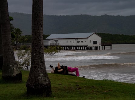
Beyond wind damage, the threat of coastal inundation remains a primary concern for authorities. Rising sea levels, a direct consequence of global heating, exacerbate the impact of storm surges. When Tropical Cyclone Narelle arrived, it did so near a high tide, pushing seawater into low-lying coastal areas and threatening to contaminate freshwater systems and damage maritime infrastructure.
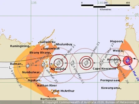
The Path of Tropical Cyclone Narelle Toward the Northern Territory
The current trajectory of Tropical Cyclone Narelle takes the system westward into the Gulf of Carpentaria, a body of water known for its ability to rapidly rejuvenate weakening storms. On Friday evening, damaging gales of up to 120 km/h were reported between Weipa and Cape Keerweer. The Bureau of Meteorology expects the system to regain Category 3 status once it is back over open water, posing a renewed threat to the Northern Territory’s east coast.
A second landfall is currently forecast for late Saturday night or early Sunday morning near the island of Anindilyakwa (Groote Eylandt). Residents in these remote island communities have been urged to finalize their preparations, secure loose items, and ensure they have enough supplies for several days of isolation. The storm is then expected to track over the "Top End," moving toward the town of Katherine, south of Darwin.
The timing of Tropical Cyclone Narelle is particularly challenging for the Northern Territory, which has already been battered by a series of major flooding events over the last few months. The ground in areas around Katherine and the Daly River is already saturated, meaning any additional rainfall will likely result in immediate and major flooding. Forecasters are predicting between 100mm and 200mm of rain as the system passes through the heart of the Territory on Sunday.
Emergency Response and Community Preparedness
Despite the severity of the wind and rain, Queensland authorities confirmed that no high-risk rescues had been required by mid-afternoon Friday. This is largely attributed to the high level of preparedness among Cape York residents and the timely issuance of emergency warnings for Lockhart River, Port Stewart, and Coen. Local disaster management groups had been meeting for days leading up to landfall, coordinating the prepositioning of food, fuel, and medical supplies.
In the Northern Territory, the focus has shifted to the "saturated heart" of the region. Katherine, a town with a history of devastating floods, is on high alert. Emergency services have begun door-knocking in low-lying areas, and evacuation centers are being readied. The threat in the NT is twofold: the immediate impact of destructive winds near the coast and the subsequent inland deluge that could cut off major transport routes, including the Stuart Highway.
The logistical challenges of responding to a storm like Tropical Cyclone Narelle cannot be overstated. The Cape York Peninsula is one of the most rugged and inaccessible parts of Australia. Many roads are unpaved and become impassable during the wet season, even without a cyclone. Aerial assessments of the damage are expected to begin as soon as the weather clears, but it may take days for ground crews to reach the most isolated outstations and Indigenous communities.
Long-term Outlook and Regional Recovery
As Tropical Cyclone Narelle continues its westward journey, the focus will eventually shift from immediate survival to long-term recovery. For the cattle industry in far north Queensland, the loss of fencing and livestock shelter is expected to be a significant economic blow. For the remote communities, the destruction of roofs and power infrastructure will require a massive mobilization of tradespeople and materials from the southern parts of the state.
The broader implications of Tropical Cyclone Narelle also touch on the resilience of northern Australian infrastructure. With storms becoming more intense due to climate factors, there is a growing call for increased investment in cyclone-rated housing and more robust telecommunications networks for remote areas. The fact that residents like Debbie Jackson had to resort to sheltering in shipping containers highlights the gap in available storm shelters in the far north.
For now, the priority remains the safety of those in the path of the storm as it moves into the Gulf. Authorities continue to monitor the system’s re-intensification closely. While the "threading of the needle" in Queensland saved many, the residents of the Northern Territory are now bracing for their turn against one of the most powerful meteorological events of the year. The coming 48 hours will be critical in determining the final toll of Tropical Cyclone Narelle on the Australian continent.